Atlas Site
Home >
USA >
California > Los Angeles
Return to Previous Page
|
|
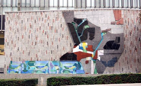
TITLE: Topographical Map
ARTIST: Joseph Young 1962
LOCATION: Los Angeles County Hall of Records. 320 West Temple Street Los Angeles, CA 90012
DESCRIPTION: Topographical Map is a 20’ h by 80’ w high-relief mosaic and granite mural located on the northern face of the Hall of Records. The mural depicts a bird’s eye view of the geologic features and water resources of Los Angeles County. Mountainous areas are black, valleys are brown, and the Pacific Ocean is a colorful mosaic of green and blue tile. Pinkish granite represents the County’s northern boundary at the Sierra Mountains.
Artist Joseph Young worked closely with the building’s architects, including Richard Neutra, to achieve a design for the wall. Young first designed the mural to portray only geological features and later added water sources to tie the mural together with the reflecting pool Neutra placed at the wall’s base. The mosaic’s map imagery was inspired by the records and maps kept within the Hall of Records.
In 2007, conservator Donna Williams was hired to clean and restore the piece while Internal Services Department (ISD) managed the restoration of the reflecting pool and the work’s fountain elements. All work was completed in 2008 and for the first time in 20 years, water flowed through the mural.
Text and images courtesy of: LA County Arts Commission
Related Website
CONTRIBUTOR: John O'Brien - Kew, Surrey, United Kingdom |
Return to Previous Page
|
The photos on this page are used by permission of the named contributors. All photos are copyrighted and can not be copied or distributed without proper authorization of their rightful owner.